


Indentifying Highly Biodiverse Savannas in the Llanos
The implementation of the SuLu project in Colombia developed and adapted methodologies and tools to identify highly biodiverse savannas as ‘no-go’ areas according to EU RED and allocate biodiversity and carbon values on a regional level. The produced Sulu map can give policy recommendations for land use planning as well as technical recommendations for the mapping process of savannas. The complete report will be published here soon as well. The information obtained during the SuLu project shows significant progress in the methodology to determine biodiverse savannas and high carbon stocks. The conceptual background and technical guidance is described in the report Identifying Highly Biodiverse Savannas based on the European Union Renewable Energy Directive (SuLu Map) as well as in it´s Executive Summary.
You also find a summary of the work from WWF Colombia within Sulu in the September bulletin of “inaction” or – in Spanish – on the WWF Colombia website
Mapping Global Grasslands
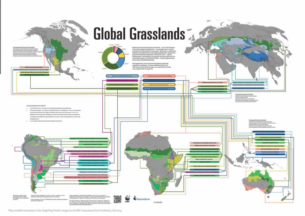
Map: world grassland types
National and international policy frameworks, such as the European Union’s Renewable Energy Directive, increasingly seek to conserve and reference ‘highly biodiverse grasslands’. However, to date there is no systematic global characterization and distribution map for grassland types. To address this gap, with the support of the Sulu project, scientists from WWF and NatureServe propose a systematic definition of grassland.
As described in the paper “Distribution mapping of world grassland types” recently published in the “Journal of Biogeography“ they integrate International Vegetation Classification (IVC) grassland types with the map of Terrestrial Ecoregions of the World (TEOW). With a new globally consistent definition for grassland, and a map of where natural grasslands are, we can develop more robust grassland conservation strategies in the spirit of the ecosystem approach outlined in the Millennium Ecosystem Assessment. We can also begin to operationalize policies like the EU RED which seeks to conserve grassland biodiversity in light of recent and global biofuels cultivation expansion. Read the full paper here and get the map as a download here
Monitoring Spatial Planning in Indonesia- Sigaptaru
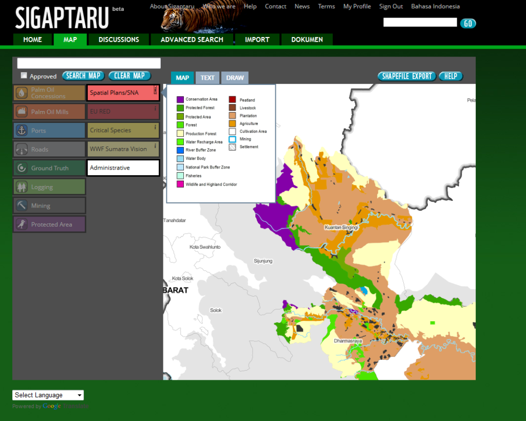
Sigaptaru.or.id
SIGAPTARU (Bahasa: Sistem Jaringan Penataan Ruang) is a web-based platform that aims to provide access to all parties in monitoring the implementation of spatial planning at the district level. The system will help to ensure appropriate licensing for land use allocation and monitor new development to ensure it follows government regulations.
Sigaptaru is encouraging community participation in spatial planning for sustainable development and is open to everyone interested – NGOs, local communities, universities and students, central and local government, association planners and civil society in general. The participation of all stakeholders ensures that land use maps and the management of spatial planning is shared and that all members of the local community benefit from the shared vision for development.
SIGAPTARU is currently focuses on the three-districts Dharmasraya in Sumatra Barat, Kuantan Singingi in Riau and Tebo in Jambi. It hosts the Sustainable Rural and Regional Development – Forum Indonesia (SRRED-FI) – a communication medium for stakeholders to bring sustainable development to all rural and regional areas of Indonesia. SRRED-FI aims to establish a common vision and actions to realise balanced economic, social, and environmental development.
Sigaptaru website: http://www.sigaptaru.or.id – Download: Sigaptaru User Manual in Bahasa and User Manual in English
Land use commitments. A comparison of EU RED, CBD Aichi targets and REDD+
The report Land use commitments, safeguards and standards: EU RED, CBD Aichi targets, and REDD+, produced by UNEP WCMC within the SuLu project reviews the three intenational policy commitments – each associated with demands for land.
Together they have both, complementary and conflicting impacts on the following environmental goals: mitigating climate change, maintaining biodiversity and ecosystem services, restoring degraded ecosystems and promoting sustainable. There is potential for the three policies to be mutually reinforcing if their standards and safeguards are effectively implemented. Moreover, there is significant potential for sharing best practice and lessons learned between the different sectors, and potential synergies and trade-offs between these policies are beginning to be explored. This is particularly important given the potential severity of land-use competition between REDD+ projects and production of bioenergy feedstocks.
Spatial planning that explicitly addresses the requirements of each can help identify where conflicts and synergies are most likely to occur in a local context. Safeguards and sustainability standards aim to limit conflicts, but their effectiveness has yet to be proven and will depend on national interpretations and application.
Building mapping capacity for sustainability in Indonesia
The report “Promoting sustainable land use planning in Sumatra and Kalimantan, Indonesia. Building mapping capacity for sustainability” demonstrates the application of EU RED criteria across the geographic regions of Sumatra and Kalimantan. Since data used are derived from various scales, as well as some official datasets without validation or accuracy assessment, these mapping results are only indicative. However, the indicative map can be used as guidance for economic operators, land use planners, or certification bodies for identifying areas that are particularly sensitive, or that are more likely to be counted within the EU RED framework of biomass production. The results of the analysis clearly indicate that in Sumatra and Kalimantan there is very little area left for a sustainable expansion of the biofuels palm oil sector bound for the European market. There are plenty of areas in direct need of sustainable land use planning – for protection from deforestation and degradation – but that there are also likely areas suitable for agricultural production with appropriate planning.
The report “Promoting Sustainable Land use Planning in Central Sumatra, Indonesia. Building Mapping Capacity for Sustainability” covers three districts in Sumatra in order to create a landscape-level map of EU RED criteria, Dharmasraya District in Sumatra Barat, Kuantan Singingi District in Riau, and Tebo, in Jambi. They adjacent districts provide three different experiences for promoting sustainable land use planning and they are all in the Rimba Integrated Ecosystem Area or Rimba Corridor (RIMBA). The corridor has been chosen as a training area where an Ecosystem-Based Spatial Planning concept will be implemented. A geographic analysis of the EU RED is presented to determine the spatial areas that meet sustainability criteria on an international level. Additionally the Integrated Valuation of Ecosystem Services and Trade Offs (InVEST) was used as input to describe potential ecosystem services such as area for restoration, areas of carbon storage, and areas that help maintain water quality and availability. The results demonstrated that a significant portion of each district contains valuable conservation targets and that each district has some mismatched licensing, or spatial planning designations indicating future conversion of forest cover. The study aims at helping stakeholders and decision makers to be more ecologically aware during the spatial planning process. Natural resources are limited and sustainable land use planning, as envisioned in Law No. 23 year 2007, is of the utmost importance.
Policy Review and Guidelines on Sustainable Land Use in Indonesia
Indonesia is one of the top producers of palm oil globally, and the EU is one of the major export markets for this commodity. The EU has issued a directive (EU RED) that comprises a set of guidelines for the users and importers of agricultural commodities, and also for plantation owners to address the negative environmental impacts of the EUs biofuel requirements. The Indonesian government has also issued several regulations that aim to control the negative environmental impacts from economic growth and the production of palm oil – but the reach of these measures is limited by a lack of human and financial resources.
The goal of the analysis “Policy Review and Guidelines on Sustainable Land Use in Indonesia” is to determine whether Indonesian laws and regulations that relate to spatial planning, protected areas and renewable energy are aligned with the technical specifications of the EU Directive 2009/28/EC (EU RED) on renewable energy (chapter 1). The analysis also outlines certain provisions contained in the laws, governmental decrees and presidential decrees, which need to be considered for spatial planning in provinces with corridors, like RIMBA (chapter 2). The concept of sustainable land use principles in spatial planning needs to be understood at a local level. Since there is still a low level of awareness of these principles and its criteria, a sustainable land use planning guideline was developed (chapter 3) to increase awareness of the spatial planning regulations and the substance of the laws. Civil Society also plays an important role in spatial planning, that´s why another focus has been on the socialization of ecosystem-based spatial planning and stakeholder involvement (chapter 4). The study is expected to provide an overview and better understanding for government parties, planters, spatial planners, universities and civil society of existing laws, regulations and decrees, and the concept of more sustainable spatial planning in Indonesia.
New frog species discovered
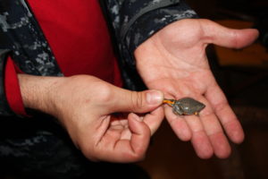
During a pilot test of the Sulu team in the Colombian project region, the Orinoco, biologists discovered a new frog species. The mini-frog belongs to the burrowing frogs in the Microhylidae family. Frogs of this group bury themselves in the ground to survive the dry season. When it rains, they hide in termite mounds, their favorite source of food.
The Sulu team has been on a farm in the Orinoco savannas for a biological survey when Camilo, the six year old son of the farm owner, found the frog in his swimming pool. For WWF the new frog species emphazises the high biodiversity of the region. The savannas and wetlands of the Orinoco are threatened by expanding cattle ranching and palm oil plantations. “A lot of species go extinct before we have a chance to discover them”, explains Daniel Cuentas. Sustainable land use planning is needed to identify and conserve areas with high biodiversity and carbon. Articles about the new frog species:
– El Tiempo (Spanish)
– Spiegel (German)
– National Geographic (English)
EU RED Carbon Calculations
The Kiel Institute for the World Economy (IfW) shows in three working papers how to calculate a carbon map according to the sustainability requirements for biofuel production adopted by the European Commission (EU-RED) for the Sulu project regions in Colombia, Indonesia and Brazil. Based on the carbon map and the carbon balance of the production process, maps are derived showing the possible emission savings that would be generated by biofuels based on palm, soy and sugar cane if an area were to be converted to produce feedstock for these biofuel options. The maps are evaluated according to the criterion contained in the EU-RED of 35% minimum emission savings for each biofuel option compared to its fossil alternative. Besides the potential emission saving, all agricultural production should be subject to sustainability assessments where carbon is only one factor besides important ecological and social criteria.
“EU Biofuel Policies in Practise – A Carbon Map for the Llanos Orientales in Colombia”
“EU Biofuel Policies in Practise – A Carbon Map for Kalimantan and Sumatra”
“EU Biofuels in Practise – A Carbon Map for the Brazilian Cerrado”
Defining Conservation Areas in the Orinoco
The report “Defining Conservation Areas in the Orinoco. Analysis of studies completed or in progress.” puts together different studies and initiatives that desrcibe priority areas for conservation in the Orinoco. The report identifies differences and similarities of the used methodologies with the aim to understand and explain how these several efforts could be used to include biodiversity data in a better way into conservation planning and how its data could be used on different levels in the SuLu project.
A Framework for Land Use Mapping
The Institute for European Environmental Policy (IEEP) prepared a report to guide the mapping of appropriate land use that aims to ensure the production of sustainable biofuel feedstocks with minimal environmental impacts. The report ‘A Framework for Land Use Mapping’ sets out principles to govern the process of mapping, such as the involvement of local stakeholders and the responsible environmental authorities, as well as criteria on data collection and processing to establish whether maps are fit for purpose. It also discusses how the European Commission could go about assessing land use planning maps submitted by biofuel certification schemes. Strict principles and criteria need to be followed in order to make mapping initiatives work for the environment and for the protection of important habitats and carbon stocks.
Drivers of Land Use Change
The Colombian SuLu team analysed the historical and socio-economics determinants of land use change in the Orinoco region. The report gives an overview about the changes in land use over the past years, about drivers for it like population growth, increased crop cultivation and mining activities. Download the report here: “Historical and socio-economic Drivers of Land Use Change in the Colombian Orinoco Region”
The “Kiel Institute for World Economies” investigates the relationship between land use change and economic development in Brazil. The descriptive analysis gives an overview about data analysed and identifies a complex interplay of different developments of the agricultural sector and land use change in Brazil.
The Report “European Biofuel Policies or What Really Drives Deforestation in Indonesia” identifies the agents and drivers of deforestation in the last years nd explains the international and national driving forces behind the direct
causes of deforestation. On that basis different policy options to reduce deforestation in Indonesia are discussed.
Legal Framework Report
The Colombian SuLu team analysed the Legal Framework of Land use Planning in Colombia with a focus on the Orinoco region. Download the report here: “Analysis of the Legal Framework of Land use Planning: A Synthesis.”
SuLu Data Gap Reports
The available geographic information for the pilot regions Kalimantan and Sumatra and the Orinoco basin in Colombia for the SuLu project are decribed in the first version of the Data Gap Reports. Read more in the reports about Colombia and Indonesia.
SarVision Report and Map – Kalimantan
SarVision developed an above ground biomass map at high spatial resolution (50m) covering entire Kalimantan (Indonesia) for the year 2008. They used an innovative approach that combines a vegetation structural type map derived from recent ALOS PALSAR radar satellite imagery and the ICESat-GLAS space borne LIDAR height measurements that can be directly related to above ground biomass. Find more information in their report.